Posted by John Humphress on Aug 1, 2010
From the National Weather Service Weather Forecast Office in Louisville.
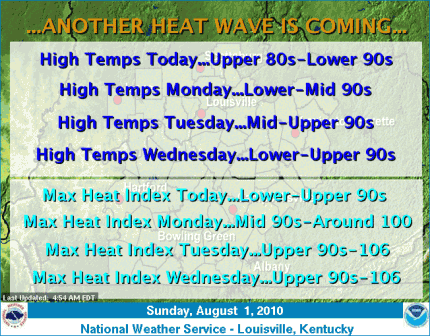
Another Heat Wave is Coming! Under a partly to mostly sunny sky today, expect high temperatures this afternoon in the upper 80s to lower 90s. Isolated late afternoon and evening thunderstorms are possible over eastern sections of south-central Kentucky, east of Glasgow. The heat and humidity will build early this week. Afternoon high temperatures will be in the 90s Monday through Wednesday, with upper 90s in some areas around and west of Interstate 65. Maximum heat index values Tuesday and Wednesday afternoons will range from 103-106 in counties around and west of Interstate 65 (including Louisville and Bowling Green), with upper 90s/near 100 index values in the Bluegrass area (including Lexington). Take the proper precautions to protect yourself from heat-realted illness. Drink plenty of water and reduce strenuous outside activity during the heat of the day. NEVER leave small children or pets in a car with the windows rolled up during the afternoon heat! Remember, Beat the Heat…Check the Back Seat!

Read More
Posted by John Humphress on Jul 31, 2010

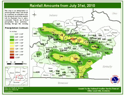
Click map to enlarge
Posted by John Humphress on Jul 31, 2010
From the National Weather Service Weather Forecast Office in Louisville
Has it seemed unusually warm so far this July? The heat has not been record breaking, as only once did a record get tied for Louisville…the maximum low temperature for July 23 tied the previous mark of 81° set twice before, back in 1991 and in 1901. However the low temperature at Louisville stayed at or above 70 degrees from the 4th through the 29th. That string of 26 days is tied for the fourth longest such streak. The record is 36 days in a row, set back in 1935. A shorter streak is ongoing at Bowling Green, 19 days, back to July 12. However, that streak is still up there though as far as records go, tied for 5th place. The record streak for Bowling Green ended on August 11, 2001, at 26 days in a row.
Longest consecutive day streaks for minimum temperatures at or above 70 degrees at Louisville:
1. 36 days (ending on August 21, 1935)
2. 32 days (8/21/1995)
3. 30 days (7/20/1921)
4. 26 days (current streak and 8/7/1955)
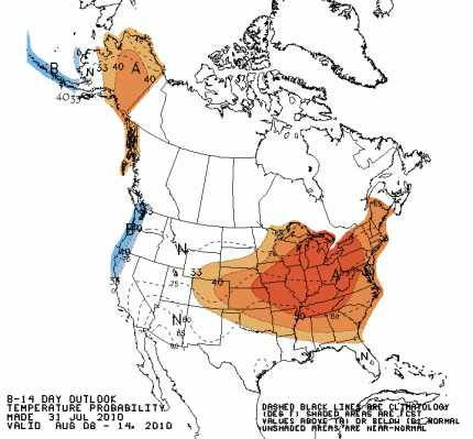
What are the chances of us setting the record at Bowling Green? They look pretty good right now. The current 7 day forecast issued by your National Weather Service keeps the official station at Bowling Green at or above 70 degrees each day. The 8-14 day outlook, issued by the Climate Prediction Center and pictured below, has readings averaging above normal for the period August 8-14. Normal lows for early August are 66 and 67 for Bowling Green.

Read More


